


This stone on the highest point on Monument Mountain was apparently installed as a surveying point to create the upper limit of Sheffield’s Upper Parish. The parish and some northern unincorporated land was set off as a separate town, Great Barrington, in 1761.
On the highest peak on Monument Mountain, there's a stone post. It's not on Peeskawso but to the northwest at the topmost point, near the “530” elevation indicated on U.S. Geological Society topographic maps, on land once owned by the Swann family that I believe has been acquired by the Stockbridge Munsee.
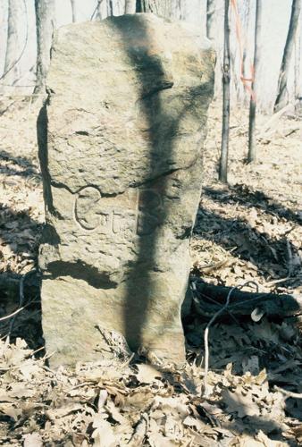
The post is 3 feet tall, 10-by-18 inches at the base, bearing “Gt B” on the south side and “St” (quite weathered) on the north. It is directly on a boundary line between Great Barrington and Stockbridge.
I found it during explorations of Monument Mountain and environs several years ago.
The marker came to mind in 2006 in email conversations with the late Lion G. Miles, a retired airline pilot living in Stockbridge who was a dynamo in his research into 18th century Berkshire history. We had a lengthy discussion of a map and its delineation of a “heap of stones.”
The map was drawn by surveyor Timothy Dwight in October 1736 and is in the Dwight Collection held in a steel cabinet at the Norman Rockwell Museum. The incorporated town of Sheffield had as its northern boundary an east-west line that crossed the Housatonic River at today’s Scarlet Bridge.
How exactly east-west it is today is a variant of the shift of magnetic north. But it was a straight line, signifying the original northern border of Sheffield. That marker is called “A monument of stones North of Moses King 60 perch” on the Dwight map.
There is also a boundary indicator at the Town House Lot, next to the Water Street Cemetery in Great Barrington — and it is directly south of the stone on hill 530. The truncated stone is in the ground near a pedestrian gate into the edge of the graveyard.

A companion marker, due south of the Monument Mountain stone, is beside a pedestrian gate at the Water Street Cemetery on State Road in Great Barrington.
The Upper Parish, between Sheffield and Stockbridge, was unincorporated, but nevertheless was settled, by English and Dutch. It was carved into “Long Lots,” and, with some upper lands of Lower Sheffield, was incorporated as Great Barrington in 1761.
Miles located the surveyor’s written report, dated June 22, 1736: “[W]e went to Houssatonnoc in April last, and surveyed the Lands in Sheffield which said Houssatonnoc Indians resigned to the Government; the next day we began at a heap of Stones about sixty rods North from Moses King’s, which heap of Stones is reputed to be the North boundary of the Town of Sheffield [near Water Street Cemetery], thence we measured to Joachim Vanvalkumbury’s [van Valkenberg] which is near the Place where some of the Houssatonnoc Tribe now dwell [north of Housatonic village]; from thence we measured Eastwardly four hundred and fifty rods, and there made a Monument which is the Station from whence the Township is described [and where there is a stone pillar today], and a Plat herewith exhibited, and made by Timothy Dwight Surveyor.”
There are 230 rods in a mile. The markers are about 1.4 miles apart.
The mountaintop marker is not mentioned in Maria L. Carr’s exhaustive new book, "Marking Stockbridge’s Past" (Fulton Books, 2023), but through no lapse on the part of the author. Very few people are aware of it.
Massachusetts Bay Colony in 1651 directed that towns establish permanent markers at their boundary corners. Since then, many town boundaries have changed for various reasons. But the markers are still obligatory.

Timothy Dwight’s survey shows Stockbridge and Sheffield boundary lines in 1736. It is in the Norman Rockwell Museum archive.
Carr began researching Stockbridge’s markers in 2011 and ventured afield, often in company with the late Helen Pigott, to seek out so-called preamble markers at each of the town’s corners. Eagle scout James J. Thomas had made his own documentation in 1975, but they found them — all but a missing one near West Stockbridge. The 24 markers are dutifully photographed and oriented on small locus maps. One was encased in highway pavement. A 25th one was missing on West Stockbridge Mountain.
Carr’s enthusiasm for her project obviously took her outdoors (there’s a section on watering troughs) but also indoors to survey the remarkable number of commemorative metal plates in municipal, institutional and church buildings (mounted credits for stained glass windows are included). Color photos abound. They encapsulate the town’s history, often in unexpected places (Shaggy Dog Studios, Alexander Sedgwick Reservation, Burgoyne Pass).
The only other local historian I’m aware of who has done a similar search for town boundaries recently is Barry Emery. He described his perambulating experiences in the company of Richard Salvi in "History of Cheshire’s Incorporation and the Shape It’s In" (Emery, 2012). Of the town’s 22 cornerstones, four were missing.